-
About us
-
About us
Downer is the largest provider of integrated services in New Zealand and employs more than 10,000 people from Kaitaia to Invercargill.
Learn more
-
-
What we do
-
What we do
Downer is a leading provider of integrated services in Australia and New Zealand.
Learn more -
-
-
Investors
-
Investors
View our latest ASX announcements as well as financial reporting, key dates and shareholder information.
Learn more
-
-
News and media
-
News and media
Keep updated with our latest news.
Learn more
-
-
Sustainability
-
Sustainability
We understand the importance of having a responsible and forward-thinking approach to sustainability.
Learn more
-
-
People and careers
-
People and careers
Our people are at the heart of everything we do.
Learn more
-
-
Contact us
-
Contact us
Downer has over 120 sites across New Zealand with our head office based in Auckland.
Learn more
-
Contact us at 0800 425 622
Underground Service Locators (USL) is one of the largest providers of underground cable, pipe and utility locating services in New Zealand, supporting Network Service Providers, contractors, councils, and private individuals during civil projects.
Our team of 30 operates across New Zealand, using technologies such as CCTV, Hydrovac and GIS mapping to safeguard vital infrastructure during construction works. With a third of our technicians certified by BeforeUDig, we are a trusted delivery partner.
Our solutions ensure that all existing utility services are protected before any construction works take place. We offer a full range of services from potholing to more comprehensive inspections using radar, virtual inspections, CCTV and hydro excavation.
Core services
Utilities Services location: We can locate power, gas, sewers, fresh and stormwater pipes, private cable networks and telecoms cables.
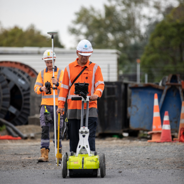
Ground Penetrating Radar: Used to identify both metallic and non-metallic buried utility infrastructure. It can also be used to locate voids and cavities foundations, storage tanks, culverts, excavation routes, pipe routes and large, solid objects.
Utility Mapping and Geographical Information Systems: Mapping of utilities and service routes including gas, water, telecoms, electricity and drainage with output to CAD or into GIS systems.
Utility Standovers: Assistance in an observational capacity to ensure work is completed according to health and safety guidelines, for example, excavations taking place near a high-voltage electricity line.
Virtual Trial Pits: This service avoids the need for excavations when detailed information within a local are a is essential. We can undertake surveys using GPR systems and provide a detailed CAD drawing or GIS output to assist with design.
Concrete Scanning: Useful in locating conduit, post-tension cables, reinforcing steel and the identification of anomalies or voids in concrete surfaces.
Additional services
Underground CCTV/Condition Assessment and Sewer Lateral Locating: Inspection services to determine if underground ducts, sanitary sewers or HVAC ductwork requires repair or replacement, detailed reports include drawings, GIS and video.
Hydro Excavations: Vacuum excavation is a non-destructive and accurate process to safely locate underground utilities using pressurised water to break up and vacuum away soil, exposing the exact location of utilities.
Geophysical Ground Investigations: Terrestrial and borehole geophysics to support environmental and engineering projects. The output is a 2D or 3D geophysical data acquisition that enhances understanding of subsurface site characteristics.